Skip to main content
Út um allt ... höfuðborgarsvæðið
en
is
Enter a search string
Walk
Bike
Municipality
Reykjavík
Mosfellsbær
Garðabær
(-)
Kópavogur
Hafnarfjörður
Path Surface
(-)
Other
Asphalt
Lava
Rocky
Facet Path Surface
Duration
1 - 2 hours
2 - 3 hours
30 minutes
Facet Duration
Difficulty
Level 1
Level 2
Level 3
Facet Difficulty
Area Access
Facet Area Access
Area services
Facet Area services
Area Type
Facet Area Type
Home
Bike and Hiking Routes
Map of Bike and Hiking Routes
Outdoor Areas
Map of Outdoor Areas
About the Website
How do I use the Website?
Visit Reykjavík
Image
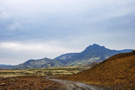
Eldborg, Stóra Kóngsfell and Drottning
Walk:
5.31km
Difficulty
Level 2
A beautiful hiking route that begins at Eldborg in Bláfjöll. The path leads through moss…
Kópavogur
Image
Fossvogsdalur
Walk:
6.27km
Difficulty
Level 1
The trail provides a great insight into the nature and history of this sheltered valley.
Kópavogur
Reykjavík
Image
Guðmundarlundur and Elliðavatn
Walk:
5.01km
Difficulty
Level 1
This circular hiking route, starting at Guðmundarlundur, goes around the uninhabited…
Kópavogur
Image
Vífilfell
Walk:
6.70km
Difficulty
Level 3
The hike to Vífilfell, an iconic mountain near the capital area, is a geologically fascinating…
Kópavogur
Image
Fossvogsdalur
Bike:
6.27km
Difficulty
Level 1
Biking through Fossvogsdalur offers a scenic ride along lush trails, with vibrant birdlife and…
Kópavogur
Reykjavík
Image
Selfjall and Sandfell
Walk:
6.19km
Difficulty
Level 2
Selfjall and Sandfell are easily accessible and scenic hiking destinations on the outskirts of…
Kópavogur